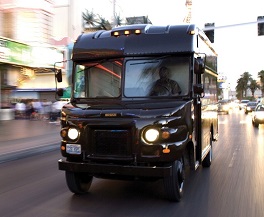
UPS today unveiled a new navigation tool called UPSNav that speeds up deliveries and cuts fuel consumption by providing drivers with detailed turn-by-turn routing directions.
According to the company, UPSNav is a significant update to its UPS’s On-Road Integrated Optimization and Navigation (ORION) software, which determines the optimal order for local UPS package car drivers to make deliveries and pickups. Using the new navigation tool, ORION gives drivers directions to their stops in precise detail – even to loading docks and receiving areas that are often on opposite sides of a building’s main entrance. ORION plus UPSNav therefore reduces the number of miles driven on targeted routes, saves fuel and enables drivers to complete their routes faster.
Drivers interact with UPSNav using the screen on their handheld DIADs (Delivery Information Acquisition Device). The DIAD mounts to the driver’s dashboard for hands-free operation and displays a map showing drivers where to turn. It emits tones to notify them when to slow for a delivery or pickup stop and exactly where to stop once they have arrived at a destination.
UPSNav uses the UPS data infrastructure and proprietary ORION maps, which include 250 million locations. Drivers and other UPS staff also can quickly correct ORION maps or update them if a delivery or pickup point changes.
“UPSNav is not a conventional navigation platform like those that guide drivers in their personal vehicles from the front door of Address A to the front door of Address B,” said Juan Perez, UPS chief information and engineering officer. “UPS drivers make an average of 125 stops each day. They often drive to customer locations that are not visible from the main road or through traditionally available mapping technology. UPSNav was built for the heavy and complex UPS workload.”
UPS launched UPSNav as a pilot this fall, rolling it out to about 5,000 U.S.-based drivers and some in Canada. UPS decided to expand the use of UPSNav more broadly after the successful pilot. Drivers on lower-density suburban and rural routes saw the most improvement. The tool was especially useful for drivers who were new to their routes, but every driver saw the benefits.
In the next iteration of ORION, due out in 2019, UPSNav will dynamically adjust throughout the day to recalculate routes, considering factors like changing traffic conditions and the remaining deliveries and pick-up requests.
“This is a major advancement for UPS routing and navigation technology. It’s been very impactful,” said Jack Levis, senior program director at UPS. “The routing and training efficiencies are undeniable. Our drivers now have the best suite of route optimization and navigation technologies in the industry.”
UPS is investing aggressively in its Global Smart Logistics Network, which relies on data, analytics and innovative technology to pioneer customer solutions, boost service levels and generate operational efficiencies.
The new UPSNav navigation tool is part of that effort alongside the recent deployment of the first phase of UPS’s Network Planning Tools (NPT), which use advanced analytics to help the company direct package volume more efficiently across its network and to make the best use of capacity at sorting facilities.


